In our series, VillageLIFE, Janet-Lynn Vorster takes us around the coastal areas of Gansbaai, Cape Agulhas, and Baardskeerdersbos in the Overberg area of South Africa’s Western Cape Province.
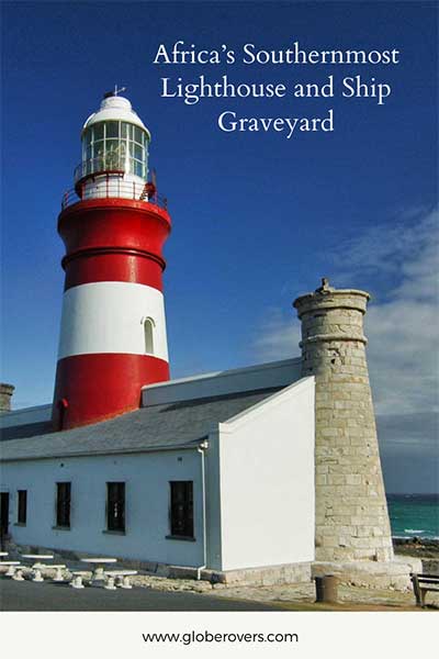
Why travel to Africa’s Southernmost Lighthouse?
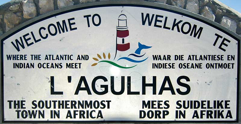
- The low-down: Cape Agulhas is home to Africa’s southernmost point and the southernmost lighthouse so it is a must-visit if you are within a 500km radius.
- The brightest highlight: Just by looking at the sign indicating that this is Africa’s southernmost point where the Atlantic and Indian oceans meet, is a great feeling.
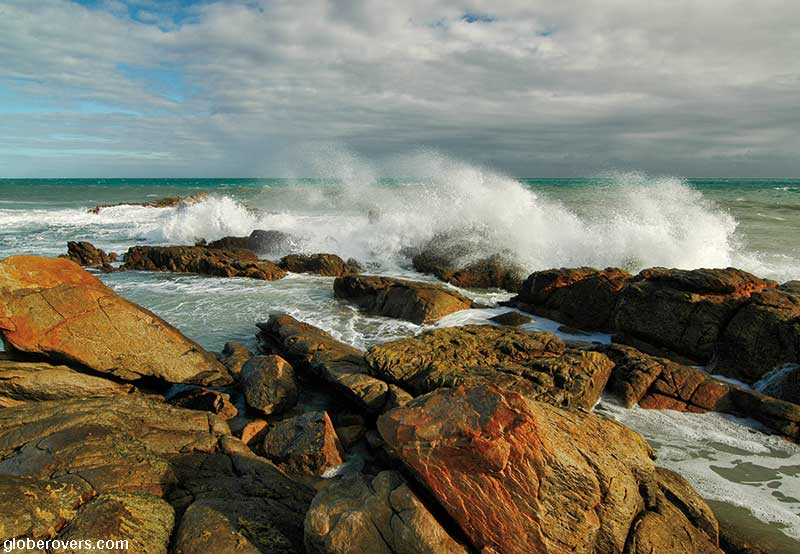
- Intrepid destination: Certainly not a crowded place. Spend a few hours hiking around the area and just enjoy the tranquillity, the wind, and the wild surf.
- Globerovers score (10 is highest): Not one of the most beautiful places in South Africa, but a must-do if you are counting your travel achievements. I’ll give it a 7.9 out of 10.
Written by Janet-Lynn Vorster
Photos by GlobeRovers, Janet-Lynn Vorster, and others
Table of Contents
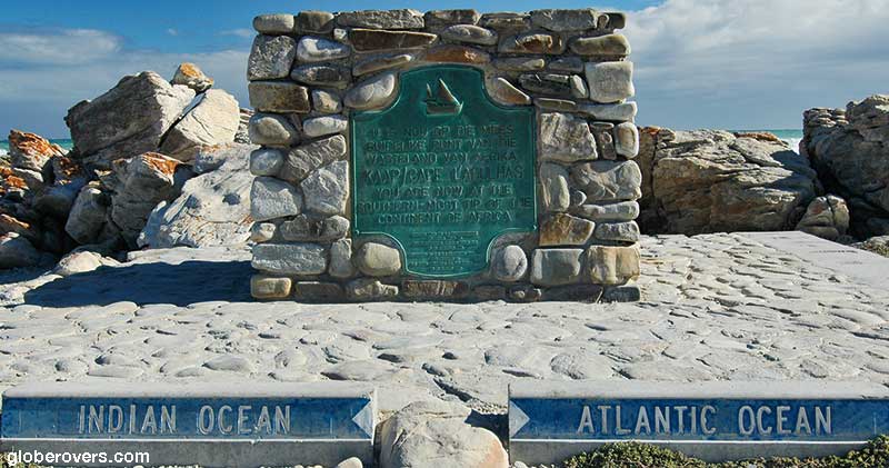
Where the Indian and Atlantic Oceans Meet
Cape Agulhas is where the Indian and Atlantic oceans meet, at this southernmost point of Africa, at 34.8163° S, 20.0152° E. Many people mistakenly believe Cape Point near Cape Town, to be the most southern point of Africa, but with coordinates 34.3567° S, 18.4968° E, it falls short of this feat.
Cape Agulhas is about 223 kilometres southeast of Cape Town, via the N2, R316 and R319 highways. About 6 km before reaching Cape Agulhas, you must pass through Struisbaai. The two towns merge almost seamlessly. What is difficult to wrap your head around, is that these two towns, lying side by side, are each bordered by a completely different ocean, with a measurable difference in ocean temperature and with very different temperaments. In the July 2017 issue of Globerovers Magazine, information is provided on these two oceans and towns.
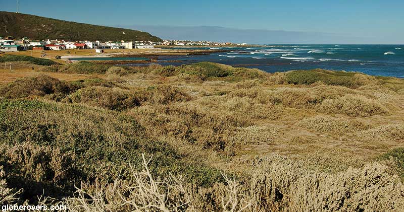
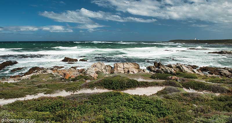
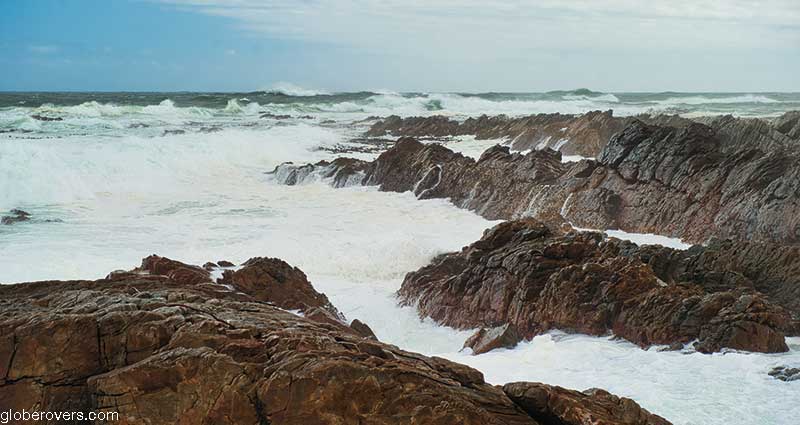
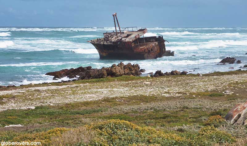
Cape Agulhas has a wild, rocky shoreline, which is shaped by the cold Atlantic; graveyard to countless ships. This treacherous coastline is safeguarded by Africa’s southernmost lighthouse which beams light deep into the night to warn passing ships to steer clear of the danger.
In 1488, Bartholomew Dias named this southernmost point of Africa after Saint Agulhas. The Portuguese christened it Cabo dos Agulhas (Cape of Needles), due to both the needle-sharp rocks and the fact that the needle of a compass does not vary between true north and magnetic north in this area. The French later renamed it L ‘Agulhas. Today it is more commonly referred to as Cape Agulhas.
Come along as we visit the southernmost lighthouse and explore some of the shipwrecks.
Cape Agulhas – Southernmost Lighthouse
This lighthouse was requested in 1837 by Colonel Charles Michell, a surveyor-general and civil engineer of the Cape Province. After years of raising the necessary funds, construction eventually started in April 1847 and was completed by December the following year. On March 1st, 1849, the lighthouse beamed out its first continuous warning signals
It has withstood violent storms and guided many vessels and fear-gripped souls to dry land and to safety: a witness to human tragedy and heart-wrenching losses.
It was declared a National Monument in 1973.
As with all old lighthouses, it was initially powered by a candle: four concentric Argand wicks producing a stationery white light of 4,500 candlepower, fuelled by burning the fat of local fat-tailed sheep in the area. This was later replaced with an oil burner, increasing the candlepower 100-fold. Today the beam has a range of 31 nautical miles (55 km) and an intensity of 7,500,000 candlepower.
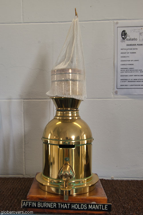
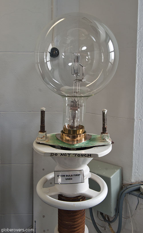
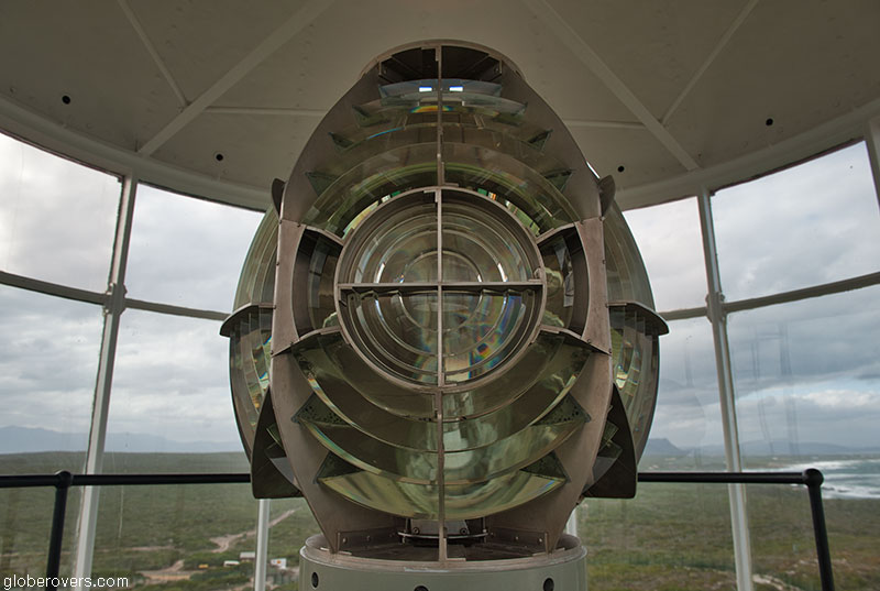
There were many modifications over the years, including upgrading the light from stationery to flashing. It was originally driven by a hand-wound weight-driven clock on a flexible steel cable revolving on a mercury float, and later replaced with an electric motor and gearbox. The types of glass used have also evolved from flat glazing to curved glazing. The source of illumination includes many other fascinating details worth reading if this article piques your interest, including the lenses used to concentrate the light into a single, piercing beam.
The design of the Cape Agulhas Lighthouse is unique in many ways. Firstly, while most lighthouses have a single tower, this lighthouse has three towers: a tall one (27 m high) and two smaller towers on each side. Secondly, it was styled on the famous lighthouse (Pharos) of Alexandria in Egypt, one of the Seven Wonders of the World and the most famous lighthouse in antiquity.
It has many Egyptian architectural characteristics, such as the pylon shape of the mock windows, the fake entrance resembling the Temple of Isis, similar frieze designs as depicted on temples and tombs in Egypt, and strong horizontal lines.
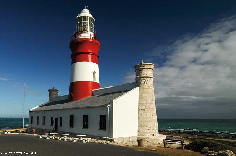
It is built from local limestone and imported Burmese teak.
At night, each lighthouse is identified by its flashing light, and by day it is identified by its shape etched on the horizon and standing out against the landscape, and the colours and shapes it is painted. Cape Agulhas Lighthouse has broad horizontal bands of red and white on its middle tower.
In 1966 the customary three lighthouse keepers were replaced by a single lighthouse keeper as electricity took over (it was electrified in 1936, actually), and fewer shipwrecks occurred due to the invention of echo sounders which allowed hydrographers to chart the oceans.
I would never have guessed some of these facts without the help of the museum at the lighthouse, and the Bredasdorp Shipwreck Museum.
Africa’s southernmost lighthouse is well worth a visit. Climb the (challenging) 71 stairs to the top and take photos.
Shipwrecks
The first recorded shipwreck on this coastline was the Zoetendal in 1673; the first of at least 140 ships to succumb to uncharted rocks, inaccurate maps, gale-force winds, storms, strong currents, and waves reaching up to 30 metres high.
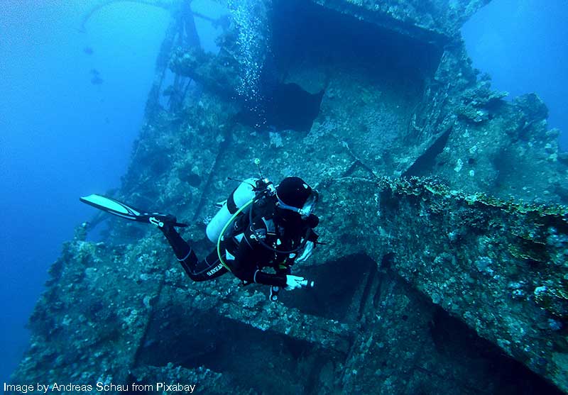
André Hartman – Wreck Diver
I went to visit André at his home in Gansbaai to get some inside stories on the shipwrecks. I got a lot more than I bargained for, and really enjoyed my visit. Even though his stroke has slowed him down, I can picture a younger version of him living a life of wild abandon.
André started as a spearfisherman and represented the South African team for five years. He “evolved into a wreck diver” as he puts it, suggesting there is a lot more to this form of extreme diving. He lives in Gansbaai, but has dived extensively in Cape Agulhas and the surrounding area.
He has lived a life of wild adventure, and is renowned as a shark whisperer, free diving with the great white sharks, and taking film crews to view the sharks and participating in documentaries. He was also the go-to person for filming dangerous snake species, catching them in Gansbaai and creating the right scenarios for film crews to get the shots they wanted.
Wreck diving and spearfishing in South Africa both have the occupational hazards of dangerous seas, and diving in the hunting grounds of the great white sharks.
In 1977, off Partridge Point, about 1.7 km northeast of Smitswinkel Bay near Cape Point, André encountered his first great white shark while spearfishing. He shot 13 fish and wondered about the absence of the usual raft of seals in the water, a certain warning of danger, but did not give it any further thought.
Towing his fish behind him on a rope, he swam his way back to land. He looked back to check his fish but instead saw movement and the big black eye of a great white shark that had been attracted by the smell of André’s fish. His thought at the time was “Wow, what a beautiful animal.” It was about five metres long. The shark came between him and the kelp, as it would when hunting seals.
So, cut off from the safety of hiding in the kelp close to shore, he wanted to pole vault over the shark with the aid of his speargun by placing the tip of it on the top of the shark’s head. A nightmare unfolded. The shark opened its mouth and swallowed the speargun and clamped its jaw down. The shark pushed André aside, reopened its mouth to swallow his arms, but André, after a moment of being paralysed by fear, moved quickly. He put his fist onto the shark’s eye. The shark spat out the speargun while André disappeared into the kelp, still towing his fish, and emerged on the closest rock.
He then swore he would never dive again, but of course he did and since then he has encountered 23 sharks on his dives. However, he has changed his tactics. He is aggressive towards them and fears losing his fish in fishing competitions more than losing his life to a shark.
André got involved with wreck diving when a friend asked him to accompany him to dive a wreck called the Reijgersdaal off the west coast of South Africa.
Shortly after this, he and a few colleagues set up a company called Sealit.
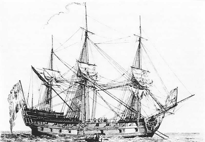
Shipwreck Joanna – 1682
The first wreck André looked for with Sealit, was the Joanna, a British East Indiaman wooden sailing vessel. The Joanna had been untouched for 300 years. André found her about 19 km west of Cape Agulhas on the third day of looking. They had to swim the coast as neither of their magnetometers were working. He found the cannons first, and then silver coins, and they dived this wreck for about three years.
Shipwreck Borderer – 1868
After diving the Joanna, Sealit, split into two, and André became part of a new company called Aqua Exploration. While looking for the next wreck, he received information on a wreck called the Borderer that another diving company had found, and salvaged quite a lot of tin. They said they had left about 100 boxes of tin behind, which is about three tons according to André, so he went to find it to salvage what was left. He took three days to find it. It sank off the coast at Arniston to the right of Bulldog Reef, three miles out to sea, where it hit a rock.
The Borderer lay 45 metres deep, but despite this great depth they managed to excavate and salvage the remaining tin successfully over the next few years, without any serious diving accidents. The time limit underwater for divers at this depth is about 60 minutes, so diving a wreck takes a long time as sea conditions also play a huge role. They had to be decompressed in a chamber on board the boat. The proceeds of the tin were used to fund their next excavation.
Shipwreck Brederode – 1785
The next wreck they found was the Brederode, lying 65 metres deep on a reef off Cape Agulhas. They were granted a permit by the government to excavate this wreck in 1991. However, an argument ensued between them and the government, and the government took their permit away. Shortly after this, UNESCO was founded, protecting any cultural, historical or archaeological underwater site older than 100 years. Now they can’t touch the wreck, which has, according to André, 130,000 pieces of Chinese porcelain and 90 tons of tin on board.
André seems to have a gift for finding ships. He pieces together his knowledge of the sea, the coast and information available. He was pivotal in finding the Brederode. Everybody thought the Brederode was on the western side of Cape Agulhas, as the ship was sailing from the east, and they thought it had hit a rock off Cape Agulhas.
He got the final piece of information, the coordinates of the wreck, in a pub in Gansbaai, by asking local fisherman if they had had any hook-ups when bottom trawling in the suspected area. A local fisherman was identified, and André went to see him. He confirmed that he had hooked something heavy, an anchor he thought. André later found this anchor close to the wreck. The fisherman found a block and tackle in his net as well. This was made from wood bound with rope, so André realised it was pre-1800. From this last bit of information, he knew he had very possibly located the final resting place of the Brederode.
With this information, André eventually found an uncharted rock in that area. He dived and found a piece of steel on top of the rock. A steel ship hit that rock a few years earlier and was badly damaged. He was quite sure that was where the Brederode had gone down. However, as the rock was uncharted, the South African Navy Hydrographic Office inserted two fictitious rocks into the map, which confused many wreck seekers. This was in an attempt to get ships to steer clear of the disastrous area.
To complete the puzzle, André remembered his friend Jimmy had found two rudder pintles on a rock a couple of years earlier. It was the very same rock, and the rudder pintles were part of the Brederode.
He told his team where to locate the Brederode, but they would not initially believe him as it was far from where she was suspected to be. So, still the Brederode eluded them. André was very insistent though, and they eventually found her based on his theory. The magnetometers could not go deeper than 50 metres. They modified the magnetometer to locate her. That is a story on its own.
Working backwards from the coordinates of the ship, he managed to piece together what happened on that fateful night.
Apparently at nine o’clock that night the crew on the Brederode saw shore breakers in front of them, and turned the ship around. He reckons when the ship turned around, they sailed for five miles in a southerly direction, and then hit a rock where they lost their rudder and punched a hole in the boat at about 11 o’clock that night. So, drifting around with the bow pointing south and without a rudder, they probably tried to turn the ship around by pulling sails down at the back, as there was a south-easterly wind blowing.
By four o’clock the next morning water was coming into the gun ports, as they were sinking slowly, so they got onto little boats and abandoned ship, and went with the wind. By the next morning they reached land to the west of Cape Agulhas, near Die Dam. This led them to presume the ship had gone down to the west of Cape Agulhas.
A few survivors got to the Cape and reported the incident. They came back looking for the ship, thinking it was five miles off the Agulhas Point. André says not to forget that they were sailing at night, and there were no lights on land. There no people or farmers living there yet. They called the entire coastal area Cape Agulhas, as Struisbaai and the other places had not been named yet. So, divers had searched for years for a submerged rock and the Brederode near what is today known as Cape Agulhas.
Afterwards, André went to the South African Navy Hydrographic Office, and pointed out the exact location of this troublesome rock to them. This is now inserted accurately into their maps.
Jaco Boshoff, on identifying shipwrecks
Jaco Boshoff is a maritime archaeologist from Iziko Museums. I met him in his office in an amazing old building in Cape Town at the top of the Social History Centre. He explained the challenges of finding particular shipwrecks. He cited the Meermim as an example. This ship is reputed to have gone down in an area in front of a river mouth. However, coastlines and river mouths change over the centuries.
Wrecks are plentiful in this area. Finding a specific wreck is not that easy. Maps were “secret” in those days, so the exact locations of the older wrecks are obscure. Shipwrecks are challenging to identify, unless you find a plate or item with a name on it, like the ship’s bell. Archaeologists build up a body of evidence, methodically, systematically and scientifically, almost like a crime scene. They must be 100% sure of their facts before announcing the finding of a particular shipwreck.
Jaco’s top three recommended shipwrecks to read about, based on interesting stories and history are:
Nossa Senhora dos Milagros, 1686: She was carrying representatives from Siam, now called Thailand. The survivors had to make a terrible overland journey to the Cape. There was a priest on board, who wrote a book on his ordeal. This ship has reportedly been found, but it has not yet been 100% proven.
Schoonenberg, 1722: Stories are rife that this ship was intentionally wrecked so that the cargo could be stolen. The wreck has not been found yet, but is believed to be around Struisbaai somewhere.
Meermin, 1766: This vessel sailed to Madagascar to purchase slaves to bring back to the Cape. The slaves revolted, and the Meermin ended up shipwrecked in Struisbaai close to the river mouth at De Mond Nature Reserve. The story of this slave ship is tragic.
On your way back from Cape Agulhas to Gansbaai or Cape Town, you will pass through Bredasdorp where you can view artefacts from various shipwrecks at the Bredasdorp Shipwreck Museum. Ask the friendly staff to take you out back to see the beautiful carriage and old fire engine.
As a last word: treasure hunting and shipwreck poaching is illegal, so don’t even think about it!
☛ Read more: Intriguing Stories of Danger Point
☛ Read more: Baardskeerdersbos – The Overberg’s Artist Town

Further reading
- Coming soon

Janet-Lynn is a numerologist by profession, and journalist, editor and photographer by hobby. She is the proud mother of three grown children and granny to three grandchildren.