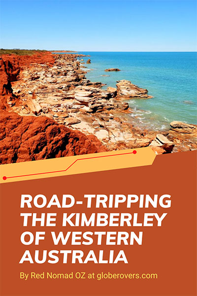
Across the Top from Kununurra to Broome
Bizarrely shaped trees lift their twisted fingers against the perfect, vivid blue dome of the sky. Semi-submerged crocodiles snooze in the sun on sandbanks and gravel bars beneath towering cliffs.
Unusual beehive-shaped formations bedded in ancient Precambrian rock dot the landscape, and fragments of a Devonian reef, once the ocean floor, rise from plains and riverbanks.
The waters of a massive lake stretch almost to infinity, scattered with islands formed by the peaks of a drowned mountain range. In the subterranean depths of a sunken waterhole, goannas laze on the rocks amidst a hidden fragment of tropical forest.
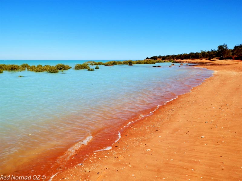
Rich red soil bleeds into a relentlessly azure ocean as one of the highest tidal ranges in the world ebbs and flows on deserted beaches and rocks indented with prehistoric dinosaur footprints. Behind a vast gulf fed by five mighty rivers, the sun sinks spectacularly in a blaze of fiery colours.
The expansive, diverse and visually rich Kimberley region in Australia’s remote north-western corner is all of these and more.
North of the Tropic of Capricorn, it is bounded by the Northern Territory border to the east, the Great Sandy and Tanami Deserts to the south, Timor Sea to the north and Indian Ocean to the west.
The pearling town of Broome in the region’s west is over 2,000 kilometres (1243 mi) north of Perth, capital of Western Australia, and 3,200 kilometres (1988 mi) west of Cairns, closer to South-East Asia than either.
More than three times the size of England and four times bigger than Iceland, it is among the most sparsely populated places on earth, with only 35,000 inhabitants in its 423,500 square kilometres (163,500 mi²), or one person per 12 square kilometres (4.6 mi²). Around 50% of the population is of Australian Indigenous descent, the oldest continuous culture in the world.
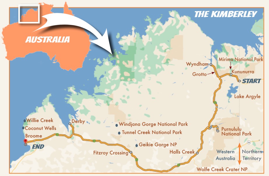
Road-trip the Kimberley from its eastern entry point at the Northern Territory (NT) border with Western Australia (WA), to Broome in the west. It is a magical 1,100 kilometres (684 mi) of superb natural attractions, varied wildlife, vast and ancient landscapes, and a fascinating history of indigenous occupation and colonial settlement.
Our Kimberley road trip began at the NT/WA border quarantine checkpoint, where vehicles entering WA are screened for prohibited items such as some fruits and vegetables.
We also gained 90 minutes by changing from Central Standard time to the Western Standard time zone.
LAKE ARGYLE INLAND SEA
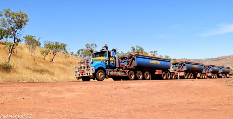
A few kilometres from the border, take the turnoff to Lake Argyle, Australia’s largest body of fresh water. A 65 kilometre (40 mi) drive through the picturesque Carr-Boyd Ranges, the lake offers accommodation, a campground, cruises, tours and other activities.
Lake Argyle normally covers around 1,000 square kilometres (390 mi²) with a water volume equivalent to 20 Sydney Harbours, though this can double during the wet season. The lake was created by damming the Ord River in an ambitious project designed to boost agriculture in the region. This remarkable feat of engineering was completed in 1971.
The lake was named for, and now covers much of the vast “Argyle Downs” pastoral property—almost the size of Belgium. The original homestead was rebuilt above the waterline, but its original location is now a scuba dive site.
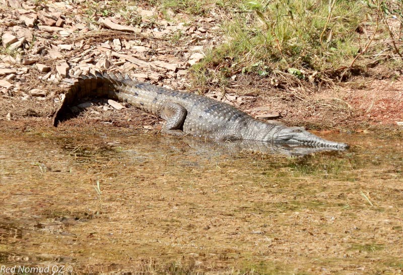
Home to an estimated 25,000 freshwater crocodiles [see inset on p. 90], the lake is also an internationally recognised wetland habitat for up to one-third of Australia’s bird species. Take an early morning cruise across the glassy water past drowned mountain peaks rising through the mist, and crocodiles sunning themselves on the banks for one of the best ways to appreciate this spectacular inland sea.
Get even closer on the first Saturday in May for the annual 10 or 20 kilometre (6.2 or 12.4 mi) lake swimming race. Don’t miss the magnificent view from the infinity pool overlooking the upper lake. It is a magical spot at any time of the day!
SCENIC KUNUNURRA
From Lake Argyle, it’s just 71 kilometres (45 mi) to Kununurra. Gateway to the East Kimberley, with a range of activities, the town’s permanent population of 7,500 doubles during the Australian winter (June to August) when travellers head north to escape the southern cold.
Established in 1961 as a service centre to support the Ord River Irrigation Scheme, its Aboriginal name means “meeting of the big waters”, a reference to periodic wet season flooding.
Nowadays the water is controlled by a diversion dam to manage Lake Argyle water flow; the 55-kilometre-long (34 mi) Lake Kununurra further upstream; and Lily Creek Lagoon on the edge of town. Recreational activities include scenic and crocodile-spotting cruises, fishing and boating, as well as swimming at a crocodile-controlled beach upstream from the diversion dam.
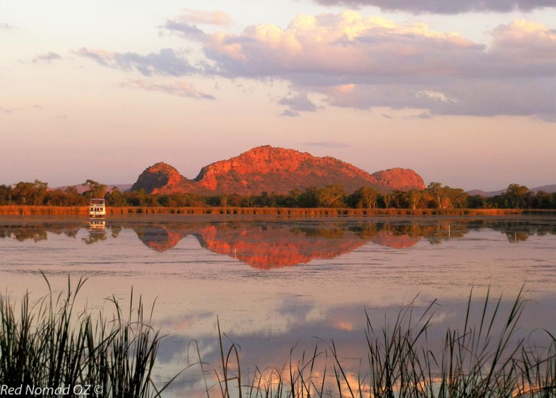
Staying on the shores of Lily Creek Lagoon virtually guarantees waterbird and wildlife sightings, including freshwater crocodiles. Concealed by lily pads during the day, their glowing eyes can be seen at night just above the waterline. The lagoon is also a superb sunset viewing spot, especially when the sun’s rays light up “Sleeping Buddha”, a rock formation resembling a slumbering figure.
Just out of town, climb to the top of Kelly’s Knob for a magnificent 360° view over Kununurra and the ranges beyond, or just to catch the sunset. Further out, lookouts at Anzac Hill and over the diversion dam’s 20-gate spillway also make good places for sunset viewing.
Nearby Mirima National Park is easily explored on foot, with unusual 350 million-year-old beehive-shaped sandstone domes similar to the larger Bungle Bungle formations further south.
Birds, rock wallabies, echidnas and even dingos live in the park. Look out for the three-metre-long (9.8 ft) python that sometimes catches some morning rays on the lookout rock platform!
Although the falls don’t flow during the dry season, the colourful Kimberley scenery at Black Rock Falls with its high black-rock amphitheatre and permanent waterhole makes up for it. It is part of Ngamoowalem Conservation Park, a culturally significant area of rocks, gorges, waterholes and waterfalls.
Thanks to an ample supply of water from Lake Argyle, Kununurra has become the food bowl of the north. Sample fresh produce at the market or farm outlets or from food stalls at the annual agricultural show held in July, a celebration of East Kimberley produce and livestock.
KILLER VIEWS AT WYNDHAM
While the port of Wyndham and surrounding attractions can be visited on a day trip from Kununurra, stay overnight to experience sunset from the Five Rivers Lookout. At over 330 metres (1083 ft) above sea level on the Bastion Range, the vantage point overlooks the town and the surrounding salt lakes and mudflats exposed by an 8.2 metre (27 ft) tidal range.
The sun sets behind the murky waters of the massive, crocodile-infested Cambridge Gulf, with five major rivers—the King, Ord, Durack, Forrest and Pentecost—draining into it.
The 100 km (62 mi) journey from Kununurra to Wyndham has many attractions, including the endemic boab trees (Adansonia gregorii), the only baobab species native to Australia with their closest relatives in India, Africa and Madagascar.
Surrounded by a fence in Wyndham Caravan Park, the “largest boab tree in captivity” is around 2,000 years old and 25 metres (82 ft) in circumference. Out of town, a large hollowed-out boab tree was once used by police as an overnight lockup for prisoners.

Set aside a full day to see all the attractions en route to Wyndham, and head west on the Victoria Highway. Pass the turnoff to the start (or end) of the Gibb River Road, 660 kilometres (410 mi) of bone-shaking, rugged, rocky tyre-shredding road that is an alternative route across the Kimberley. It is unsuitable for conventional 2WD or low clearance vehicles.
Further north, make a short detour to the “Grotto”, a subterranean waterhole straight out of middle earth, surrounded by high, rocky cliffs spectacularly reflected in the still waters. Descend 140 steps down the cliff (no handrail!) to the pool, fed by a waterfall at one end and enclosed by vegetation. Don’t let the large water monitors (lizards) sunning themselves on the rocks stop you from swimming!
Heading north, a 4WD-only detour passes the old Overland Telegraph Station on Telegraph Hill before reaching Marlgu Billabong on the edge of the Ord River floodplain.
Named for an Aboriginal word meaning “wild bird”, it is part of the 36,000 hectare (139 mi²) Parry Lagoons Nature Reserve and up to 20,000 wetland birds can be sighted here in season. Unfazed by the resident crocodiles swimming alongside them, the birds must know that crocodiles won’t waste energy on prey so small.
Wyndham’s resident crocodile, a 20-metre-long (66 ft) larger-than-life-size statue, “welcomes” visitors to Western Australia’s northernmost town, established in 1886 as a port for the Halls Creek goldfields and East Kimberley pastoralists.
Nowadays Wyndham services the live cattle export, mining and Ord River Irrigation Project industries. Visit the Wyndham Museum for more about the town’s colourful colonial history with memorabilia from the now-closed meatworks; aviation and World War II history; and pastoral industries.
When compared to the local Australian Indigenous people’s long-term occupation, however, European settlement seems insignificant.
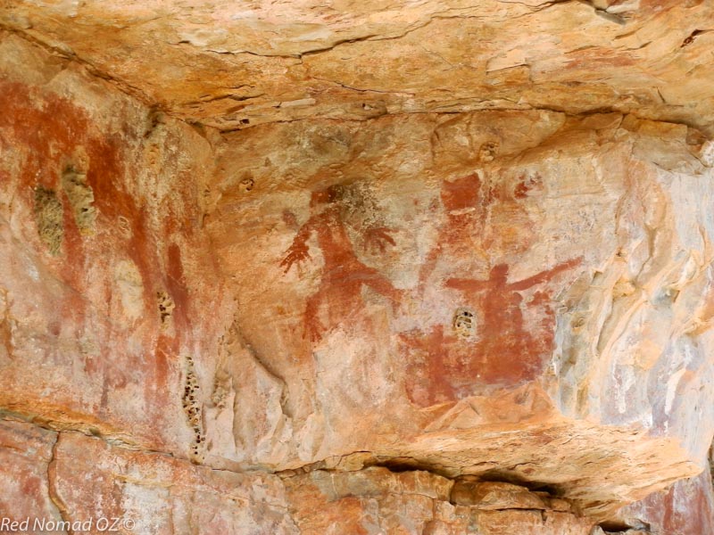
On the walls of a cave outside the town at Moochalabra Dam, some interesting petroglyphs thought to be 4-5,000 years old show historic scenes from the oldest surviving culture on earth, whose heritage dates back 50,000 years. Other rock art in the region is believed to be up to 16,000 years old—over three times older than the UK’s Stonehenge.
HISTORIC HALLS CREEK
From Wyndham, it is a 352 kilometre (218 mi) drive south to Halls Creek. En route is the turnoff to UNESCO World Heritage-listed Purnululu (Bungle Bungles) National Park with its distinctive 200-metre-high (656 ft) beehive-shaped cone karst domes formed of sandstone from the Devonian period. Hike its many trails, or take a helicopter flight over the park.
Halls Creek lies about halfway between Purnululu and Wolfe Creek Crater National Park, 152 kilometres (94.4 mi) to the south. Formed by a meteorite 300,000 years ago, the crater featured in the cult Australian horror movie, Wolf Creek (2005).
Site of Western Australia’s first major gold rush in 1885, the old Halls Creek township a few kilometres from town once housed 15,000 prospectors. While historic buildings still remain, it is now a campground. Nearby is China Wall, a 15-kilometre-long (9 mi) vein of white quartz up to six metres (20 ft) high.
From Halls Creek, Alice Springs and Uluru (Ayers Rock) to the south-east can be reached via the remote Tanami Road. To the south-west, the Canning Stock Route tracks through the Great Sandy Desert.
FITZROY CROSSING’S “ICEBERGS”
From Halls Creek, we continued 290 kilometres (180 mi) west to the small town of Fitzroy Crossing, surrounded by the Fitzroy River floodplain and established at the best place to cross the river during floods. When in flood, an estimated 30,000 cubic metres (1,059,440 ft³) of water per second flows down the river and floodplain, arguably the highest volume of any river in Australia.
Geikie Gorge National Park, about 20 kilometres (12 mi) from town, is the remains of an ancient Devonian reef laid down 350 million years ago.
Eight kilometres long (5 mi), and lined with 30-metre-high (98 ft) limestone cliffs carved out by the river, the limestone has been bleached and eroded by seasonal flooding, giving it the appearance of an iceberg. Explore the gorge via its hiking trails, or take a cruise.
Here we first learned of the legendary Indigenous warrior Jandamarra, born around 1873 and initiated into the Bunuba nation whose traditional lands include Fitzroy Crossing. His story unfolded as our journey continued into the west Kimberley.

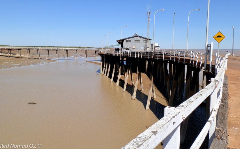
DERBY’S HIGH TIDES
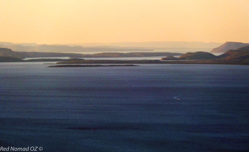
The small town of Derby, 257 kilometres (160 mi) north-west of Fitzroy Crossing, is on King Sound at the mouth of the Fitzroy River. King Sound’s 11.8 metre (38.7 ft) tidal range is Australia’s highest, and possibly third highest in the world after Canada’s Bay of Fundy, and Argentina’s Puerto Gallego.
Watch the tide’s ebb and flow—and maybe a saltwater crocodile or two—from the jetty many metres above the mud flats at low tide, and almost floating on the water when the tide is in. Be here in the late afternoon when fishing lines come out, beers flow, and the sun sinks below the sound’s murky waters.
Derby is the western gateway to the notorious Gibb River Road, the eastern turnoff to which we passed between Kununurra and Wyndham.
If your vehicle or camper isn’t up to the rigours of this rough and rocky road, take a guided tour from Derby (Fitzroy Crossing and Broome also offer tours) to Windjana Gorge and Tunnel Creek National Parks. It’s a wild ride through stunning scenery and into the heartland of Jandamarra’s exploits.

While the Lennard River only flows during the wet season, many crocodiles inhabit the pools that remain in the 3.5-kilometre-long (2.2 mi) ancient limestone reef forming Windjana Gorge, 146 kilometres (91 mi) from Derby.
At the gorge, Jandamarra led 50 Indigenous warriors in a battle against the settlers. The nearby Lillimooloora Police outpost marks a significant turning-point in his story—here, he killed an officer, and started his campaign to reclaim traditional lands.
About 33 kilometres (20.5 mi) south-west of Windjana Gorge, a 750-metre-long tunnel eroded by a creek through Devonian Reef limestone forms Tunnel Creek National Park, where Jandamarra was killed in 1897.
Explore the tunnel by squeezing through the rocky opening and wading through pools of water in the dark—bringing a torch or headlamp is highly recommended! The creek flows into the open at the end of the tunnel, but the only way back is to retrace your steps.
Back in Derby, explore the Jandamarra heritage trail and visit the old gaol, cemetery and boab prison tree.
BROOME’S BRILLIANT COLOURS
The final leg of this cross-Kimberley adventure is the 222 kilometre (138 mi) drive south-west from Derby to Broome on the traditional lands of the Yawuru people, where the desert meets the tropics on the Indian Ocean’s shores.
Thanks to its pearling history, the port of Broome has a multicultural population, a culture including Malay, Chinese, Indonesian, Japanese and European influences, and a rich Indigenous heritage.
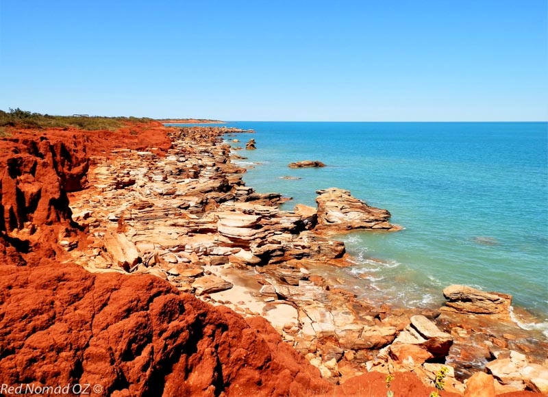
After the Kimberley’s dry-season inland landscapes in shades of red and ochre, and the muddy waters of Cambridge Gulf and King Sound, Broome’s brilliant turquoise sea has an almost shocking intensity. Offset by the intensely coloured pindan (red soil), the contrasts make a distinctive colour palette.

Among Broome’s many attractions are its beaches, including the 22-kilometre-long (13.7 mi) Cable Beach famous for camel rides at sunset; Town Beach with its “Staircase to the Moon” phenomenon, where the rising moon reflects on the mudflats; Coconut Wells beach north of Broome; and beaches on the Dampier Peninsula, stretching 209 kilometres (130 mi) north from Broome to Cape Leveque.
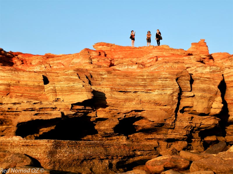
At the southern end of Cable Beach, eight kilometres (5 mi) from town, Gantheaume Point’s layered red rock formations are a favourite sunset-viewing spot.
Dinosaur footprints thought to be 130 million years old can be seen on the rocks when the nine metre (29.5 ft) tidal range is at its lowest, also the best time to see the Catalina flying boat wrecks, sunk about one kilometre (0.6 mi) offshore during World War Two.
With the largest pearl shell in the world (Pinctada maxima) abundant in Roebuck Bay and a lugger fleet of over 400 vessels, Broome once produced 80% of the world’s mother-of-pearl. The industry slowed when plastic buttons replaced mother-of-pearl in the 1950s, but in the 1970’s Broome was producing up to 70% of the world’s large cultured pearls.
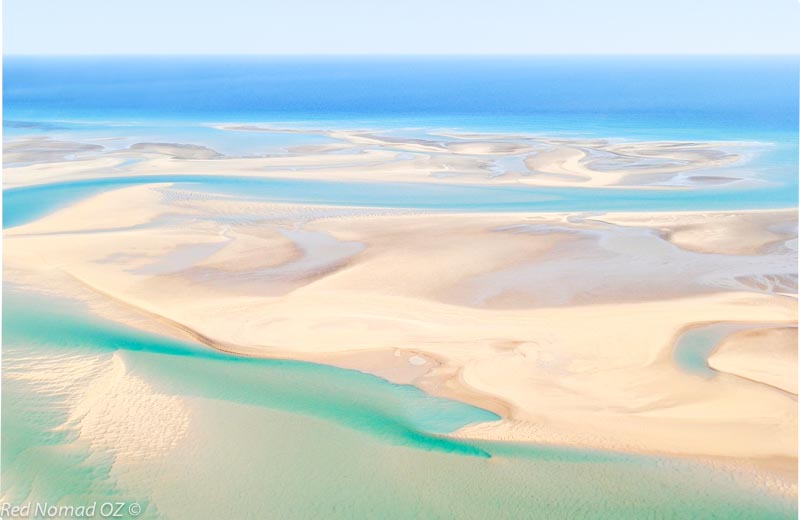
Come in August/September for Shinju Matsuri, Festival of the Pearl, or take a tour of Willie Creek Pearl Farm on a tidal estuary north of town, the colours and patterns of which are best seen from the air.
About 23 kilometres (14.3 mi) east, 333 bird species have been sighted at the Broome Bird Observatory. Amongst the top five migratory shorebird locations in the world and a significant site on the East-Asian Australasian Flyway, Roebuck Bay becomes a summer home from August to May for birds flying up to 11,000 kilometres (6,835 mi) from north of the Arctic Circle. They return home to breed during the northern summer.
And now it is also time for us to finish our journey through the diverse and colourful Kimberley and return home. One trip is not enough to fully explore the whole region, but that’s what next time is for!
HOW AND WHEN TO VISIT
Our Kimberley adventure was part of a longer road-trip through Central and Western Australia, but there are several other options for accessing and exploring the region.
Fly to Kununurra (eastern gateway) or Broome (western gateway) from major Australian cities. Hire a car or camper, and traverse the Kimberley from east to west, or vice versa. All Kimberley towns and some roadhouses between towns have on-site accommodation.
Alternatively, fly to Darwin (Northern Territory capital), hire a vehicle and drive via Katherine to the NT/WA border, about 800 kilometres (497 mi) by road from Darwin. Or instead, fly to Cairns in northern Queensland and drive the Savannah Way, a 3,700-kilometre-long (2299 mi) route across northern Australia that includes the Kimberley.
Otherwise, do as we did, use your own vehicle with tent or camper accommodation, and start the trip from anywhere! A self-guided road-trip will give you more flexibility to explore the region at your own pace, however, guided tours are also available.
The Kimberley region has a tropical monsoon climate. During the wet season (December to March/April), some roads, tours and attractions may be closed, and conditions can also be unstable during October and November. The dry season (April/May to September) has clear, sunny days and cooler nights, so is more pleasant for travelling–although a lot busier!
☛ Read more: Posts of Australia
☛ Read more: Australia by Red Nomad Oz


Marion is “Red Nomad OZ”, author, blogger and Aussie traveller who loves discovering nature-based attractions and activities – and scenic loos – all over Australia. Her Aussie travel blog and published book “Aussie Loos with Views” provide inspiration for other Aussie explorers.